 | Location maps
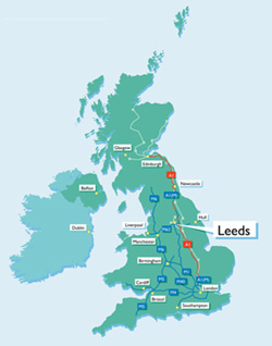
This area contains a series of maps showing Leeds as a location in relation to both the rest of the UK and Europe. There's also a city centre map and a Metropolitan district map for more detail. You'll see just how central to the UK Leeds is and also how close it is to the rest of Europe. Have you also visited our information resources section where there's a photo library which will allow you access to up to date imagery of Leeds. | |||||||||||||
| Leeds. No ordinary day. No ordinary city. | ||||||||||||||
|
You are here: Location Maps > UK The Ordnance Survey (mapping/map data) included within this website is provided by Leeds City Council under licence from the Ordnance Survey in order to fulfill its public function to (publicise local services / act as a planning authority / attract inward investment). Persons viewing this mapping should contact Ordnance Survey should they wish to licence Ordnance Survey material for their own use. |
Click here to download a PDF of this map.
| |||||||||||||
| Development Department Leeds City Council | ||||||||||||||